From the ‘Oh Ranger’ book:
Starting 65 million years ago, weather patterns shifted, and the area now called the Badlands was lifted and transformed by geological forces. The black, muddy floor of an ancient sea that once covered this area was compressed into a band of 2,000-foot-thick rock known as the Pierre Shale. Forests flourished and withered away. Volcanoes laid down a thick layer of ash and rivers repeatedly flooded the region, depositing sediment. These successive layers of matter often held the bodies and bones of animals now long extinct and preserved for posterity as fossils. Wind and the rushing waters of rivers now long vanished eroded the dry, fragile soil, coursing through different layers of harder and softer rock, gouging out channels and gulleys, and carving cliffs, spires and odd rock formations.
Erosion continues to this day, frequently revealing long-buried fossils. Drawn by the fossilized remains of saber-toothed cats, miniature camels and horses, and huge rhinoceros-like beasts known as titanotheres, scientists discovered millions of years of geologic history buried in the multicolored layers. One of the world’s richest Eocene/Oligocene Epoch fossil beds is located here, yielding a wealth of information of the ‘Golden Age of Mammals’ of approximately 25 million to 37 million years ago.
It’s so fascinating how these National Parks came to be what they are today. When we arrived at Badlands Visitor Center, the kids were happy to discover the Junior Ranger program was all about fossils, focusing of course, on those found within the Park. The Ranger chatted with them for a while, showing them samples, then gave them little ‘cakes’ of hard baked sand, which they carefully dug through to find shell ‘fossils’. It was a great activity, kept them occupied for a good while; they were thrilled to find some shells. I’ve searched for the ‘recipe’ online and can’t find anything similar, the ranger couldn’t remember the exact combination of ingredients but mentioned he used sand and Epsom salts, the search will continue – I could hide all sorts of things in there!
As well as showing all the kids (there was a small group of 7 – we were over 50% of the attendance!) different casts of fossils, he also took them out to a rocky area where a saber-tooth skull fossil had been discovered. They all eagerly looked around to see if there was anything they could find. It was a great program, well worth staying the extra time for and they were sworn in for their 50th Junior Ranger program, GO VALENTINE KIDS!
So, it was a late start to the travel day but we made good time, leaving before noon. We stopped at ‘The World’s Only Corn Palace’ in Mitchell, SD. We would certainly have passed this by had it not been suggested by the Outback couple at the campground. The first Corn Palace was built in 1892 when the city of Mitchell was just 12 years old. The idea was hatched by Louis Beckwith and L.O. Gale to showcase the crops grown in the area and to attract immigrant farmers to settle here. Along with the Corn Palace, a festival was planned to celebrate the harvest. Renowned to this day, over 100 years later, the tradition of the Corn Palace continues. The Corn Palace is known around the world as a folk-art wonder on the prairie of South Dakota.
Each year a new decorating theme is chosen and the outside of the Corn Palace is stripped and redecorated with new corn and grains. In early summer the process begins with removal of the old grasses and grains. Over the summer, 3,000 bushels of milo, rye, oat heads, and sour dock are tied in bundles and attached. The corn murals have to wait until late summer when the corn crop is ready. Over a half million ears of corn, in 12 different colors, are sawed in half and nailed to the building following patterns created by a local artist. They were a-maize-ing!
After another couple of stops en route for essentials (including wood for the floor in the camper, in an attempt to resolve a very soft floor issue around the air vent where the slide struts are underneath – not sure if it’s because we’re using the slides so often or walking over the area constantly but either way, it’s not great and a tad worrying) in Sioux Falls and across the border into Minnesota we went: state number 43.
Pipestone is a small town just over the border; the campground is along Hiawatha to the very end of town, opposite the entrance to Pipestone National Monument. By the time we rolled in, given that we lost an hour during the day, crossing back into the Central timezone, it was 9pm. The kids ran off to play in the huge sandbox while Dave and I battled the mosquitoes before I took refuge in the camper to sort out beds. When the kids came in, they were covered in bites, poor Caitlin had 5 on her face alone, ugh, we hate (this is the one time the kids will let me get away with hate – not a word we encourage the use of) the tiny, blood-sucking, buzzy things, there is more OFF in our future I fear!
States visited: 49!
visited 49 states (98%)
Create your own visited map of The United States
Miles driven so far -
LOOP 1 (Aug 2009 - Aug 2010): 29,000
LOOP 2 (May - August 2012): 10,800
Highest altitude with camper: 11,158ft (I-70, CO)
Friday, August 6, 2010
Thursday, August 5, 2010
From Hill City to Badlands National Park: Saturday, July 10th
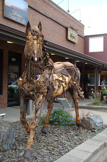
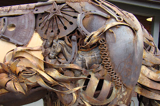
Having spent some of the early morning running around playing variations on tag (listened to the rules of ‘soccer tag’ on the drive, surprisingly – she says, tongue in cheek – similar to ‘frisbee tag’, ‘football tag’, ‘nerf tag’, ‘shoe tag’, really, shoe tag??) with the early-rising neighbors who had three boys, the kids were fine with sitting in the car for a couple of hours. As we drove through nearby Hill City, I stopped for photos of the Iron Star by John Lopez. This is a hybrid metal sculpture, featuring scrap-iron technique, infused with cast bronze pieces. Along with the farming tools and implements, we were also challenged to find five equine bronze sculptures, a man's face, flowers and iron feathers - think we succeeded.
The route to the next campground took us under a neat 'double bridge' (just outside of Hill City), through part of Badlands National Park and also past the Visitor Center
The Badlands were amazing, barren, yet beautiful, the colors were so varied, the landscape, a maze of hills and bumps of soft pale rock. Dave pulled over for a photo with the camper in tow; I love how it came out. It’s been fun to look through the different ‘backgrounds’ the camper’s enjoyed this year, a great selection indeed. Coming into the Park, we also watched a tour helicopter landing.
We stopped in at the Visitor Center just after 11am and discovered there was a Junior Ranger program each day at 10:30am, lead by a Ranger which would give the kids their badges without having to complete their book, as an added bonus, they’d also get a patch. This appealed to all of them as a fun alternative and we decided to change plans a bit and leave later to allow for them to do that in the morning. We stayed to watch the movie before leaving the park and locate the campground. The movie was one of the highest qualities we’ve seen, the sound and images were excellent. We learned how much of a diverse animal population this area supports, in both the rock areas and vast, expansive prairies.
We stayed for one night at Badlands Ranch & Resort, as Dave said, resort should be regarded in a very loose sense! It was a perfectly acceptable campground and in fact, more than we expected for the $12.50 we paid (thank you Passport America Badlands from the hill top as we drove in and out; it’s in a wonderful location.
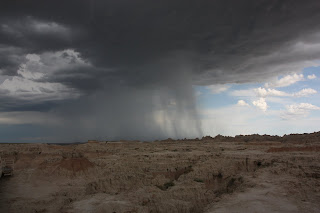
After chatting with our new neighbors, full-timers, retired, traveling in their Outback travel trailer, we headed back through Badlands NP (watching an amazing storm in the distance) to Minuteman Missile National Historic Site, the only national park unit that tells the story of the Cold War.
After chatting with our new neighbors, full-timers, retired, traveling in their Outback travel trailer, we headed back through Badlands NP (watching an amazing storm in the distance) to Minuteman Missile National Historic Site, the only national park unit that tells the story of the Cold War.
This is made up of two areas, Launch Control Facility Delta-01 and Launch Facility Delta-09. Beneath the Launch Control Facility is an underground Launch Control Center United States was attacked by the Soviet Union with nuclear weapons. Unfortunately the tour for the facility had already been completed for the day so we ‘saw’ it via the video and looked at one of the red chairs – complete with seatbelts. Belts were necessary to keep the missileer in place should the ground be shaking from an imminent crash or earthquake in order that they could still complete their tasks.
Launch Facility Delta-09 is a missile silo with a Minuteman 2 missile on display (President Kennedy referred to these as ‘Ace In The Hole’ in 1962). We saw a number of pictures of this but didn’t have time to drive out to the site on exit 116 – another time perhaps. Funnily enough, these locations were never kept secret, always just by the side of a road, usually on rancher properties. The average citizen however rarely knew what they were. There are still a number of Minuteman 3 missiles in the US
The kids Junior Ranger booklets gave a short summary of the history surrounding this site. The Cold War lasted from 1945-1991. During that time there was a long and troubled conflict between the United States and the Soviet Union . This war led to a huge weapons build up on both sides. These weapons included nuclear missiles, such as the Minuteman. The first Minutemen were deployed in 1962. Within five years a total of 1,000 were online and ready. Minuteman missiles were operational across the Great Plains region. United States policy was to only use Minuteman missiles if the Soviet Union first attacked with their own nuclear weapons.
The 150 Minuteman missiles in South Dakota United States South Dakota Launch Control Center
When the Cold War ended in 1991, a treaty was signed (Jake and I spent a while by the sign detailing this treaty, signed by Presidents Bush and Gorbachev) that deactivated these 150 missiles. It was also decided that a deactivated launch control facility and a missile silo would be kept to help tell the story of the arms race. These sites became part of Minuteman Missile NHS in 1999.
That same year a missile engineer by the name of Tim Pavek testified before the US Congress about the importance of the Minuteman Missile to the nation’s history. Here is what Mr Pavek said:
“The Minuteman was one of the most significant strategic weapons in the USA South Dakota
A number of myths were also ‘debunked’ by the Visitor Center
Were the missiles ‘top secret’?
No, they were in plain sight.
Were the missiles launched by pressing a red button?
No, two missilers had to turn a key at the same time in the Launch Control Center
If a missileer did not execute a launch command would their partner shoot them?
No! Clearly, movies do not depict facts accurately!
Did the missileers know where the missiles were going?
No, although they usually had a pretty good idea.
How many missileers did it take to launch the missiles?
Four. There was back-up center that would also turn their two keys after the first center turned theirs, thus preventing one squadron from taking matters into their own hands.
Were most missiles aimed at cities?
No, some were of course but the aim was to take out the Control Facilities first.
It was an interesting hour or two we spent there. The kids learned about a war they hadn’t even heard of prior to today and we got to see some ‘behind the scenes’ activities. The Ranger on duty, Ranger Jack, was extremely informative and posed with each of the kids as he presented them with their certificate and patch.
From here, we drove back into Badlands National Park Badlands is described as the wall, allowing you to ‘walk through a door opening’ and out to the incredible, open views beyond, an enormous expanse of pale rock as far as the eye can see. The kids were excited to climb all over this area, unfortunately we were only wearing crocs, not exactly the best or most grippy footwear. The rocks look solid from a distance but in fact are eroding relatively quickly, by 1” per year; it’s easy to see how this erosion happens, bits were coming off with every touch and step. It's easy to see the incoming storm in the photos, we saw lots of lightning strikes in the distance.
Similarly, a little further along, the window opening created a couple more different views of the landscape. As we walked over there, we passed this running car (a/c clearly needed for the pets not allowed on the trails) with their dog driving!
After checking out a couple of exhibits in the Visitor Center (Jake always curious, asking questions of the ranger), we walked around the Fossil Exhibit Trail, seeing samples of fossils of animals from long ago, some with similarities of those animals around today, others baring little resemblance to anything we’d ever seen.
After checking out a couple of exhibits in the Visitor Center (Jake always curious, asking questions of the ranger), we walked around the Fossil Exhibit Trail, seeing samples of fossils of animals from long ago, some with similarities of those animals around today, others baring little resemblance to anything we’d ever seen.
We continued our drive along the Badlands Loop Road
The Pinnacles Overlook had been recommended to us as a great location to view big horn sheep. Unfortunately, as we arrived, another storm was setting off so I’m quite sure all the animals were already taking shelter. So, no sign of any animals but great views of the lightning! As enormous raindrops began to fall, Dave stayed outside for another 15 minutes in an attempt to photograph the lightning – ever tried to do that? Quite a challenge isn’t it?!
The Badlands Loop Road Wall , so named because it was built on the edge of the northern extension of the ‘Badlands wall’. For miles along the freeway, prior to getting to this area, we’d been seeing signs for Wall Drug, at least 100 miles from the town! Their marketing certainly worked for us, as we came into the town, we drove towards the shop and went into the café they had inside. The shop took up an entire block and was filled with a maze of mini shops which we had to walk through to get anywhere within this neat store. It had such an interesting history and was barely turning any profit when the couple running it came up with the idea of offering free ice water to travelers, which brought people in for other things. They continue to offer free ice water every day and also only charge 5 cents for a cup of coffee; this keeps customers coming in and the store has grown and grown.
After dinner there, we walked through to their ‘backyard’, had pictures with their huge (fake!) stuffed rabbit, giant Jackalope replica, Mt Rushmore replica, on the covered wagon among other things. Becca and Nate were desperate to get wet in the jumping fountains but kept timing their moves around the area incorrectly (not sad about that!). We bought some of their homemade donuts to take back with us for dessert (sadly they weren’t as good as their hype) and really enjoyed our experience in this quaint/kitschy historical store.
Despite the rain, or perhaps because of it, Dave insisted we stop on the way back through the National Park for more pictures – clearly everything looks different once it’s wet! I got to be photographer’s assistant and protect the new camera from the rain – such a privilege! On the way back, we saw a beautiful half-rainbow.
Subscribe to:
Posts (Atom)


