Onwards to Capital Reef and the Grand Canyon
Thankfully with little set-up, there was also little
take-down, so we were on the road and heading out of Goblin Valley by 7am,
watching the sun peek behind the clouds and cast its rays on the rocks,
bringing out their vibrant colors – it was a gorgeous way to begin the day.


After a quick lunch stop (we see the strangest things on our travels: Hot Mama - contains hearts among other things!),

we continued on the 89, past the entrance roads to Bryce and Zion. It was insanely windy all day. I remain forever impressed at how Dave handles towing the camper in all weathers. This was probably the most challenging day we had ever had though, being buffeted constantly by the winds and not being able to travel at speed. Dave takes it all in his stride even as I grip the door handle in panic! We pulled in for pictures at Coral Pink Sand Dunes State Park but did not continue all the way out to the Park – there are just SO many wonderful places to visit in this state, and unfortunately given our initial time crunch, we had to save some for another time.


Unsurprisingly, given our remote location, we encountered
very little traffic. In fact during the
first hour, we saw just four cars.........and a mini airport! The
landscape continued to ‘wow’ us with its beauty and, as we approached Capital Reef National Park,
the steep sides of the rock walls grew higher.


On our original itinerary, this Park was penciled in but
seemed doubtful. We had checked the map
though and it made little difference to our timings to take the road through
the Park, so, never ones to pass up an opportunity, we chose this option. Before the Visitor Center,
we stopped to look at the Petroglyphs left behind from years ago. A second set are no longer evidenced after a
rock fall in 1952.


Most people enter the Park from the west, which was very
clear when we exited. Our entry from the
east took us through some tiny towns inhabited by trailers and no ‘tourist
traps’. When we travel, we always wonder
how people survive and what exactly they do in these middle-of-nowhere
locations. We understand that some
people enjoy the solitude, but they have to eat, right?! Anyway, it’s always neat to see the diversity
and for the kids (and us!) to realize that there are so many different paths in
life to choose and take. It brings up
interesting discussions about their future and how many options they have: the
path often traveled is not necessarily the right one.
Stopping in at the Visitor Center,
we were tempted by the Junior Ranger programs (they have a number of different
options), but time was pressing and we knew it couldn’t be done. We learned that a giant buckle in the Earth’s
crust stretches across south-central Utah. It was created 65 million years ago by the
same forces which later uplifted the Colorado Plateau and is called the
Waterpocket Fold. The Fold and its eroded jumble of colorful cliffs, massive domes,
soaring spires, stark monoliths, twisting canyons, and graceful arches make up
Capital Reef National Park; it was truly spectacular.

Opposite the Visitor
Center stands ‘The Castle’
towering up above everything else and the most prominent and photographed landmark
in the Park.


Passing the Fluted Wall, we pulled off at Panorama Point and
wandered up to Goosenecks Overlook which among others, gave us a great view to
Chimney Rock. The white Navajo sandstone is most common in this Park, weathering to
create the sandstone domes, ridges, and reefs.
The vibrant orange Windgate sandstone erodes to create the sharp, steep
edges that tower ever upwards. Our options beyond these main lookout points
were limited as we had the trailer in tow - it certainly looked little surrounded by these magnificent rock structures.
Capital Reef is long from north to south with a short scenic drive from east to west but
with a multitude of options for backcountry hiking and camping. I guess it’s another one on the list to come
back to!


we continued on the 89, past the entrance roads to Bryce and Zion. It was insanely windy all day. I remain forever impressed at how Dave handles towing the camper in all weathers. This was probably the most challenging day we had ever had though, being buffeted constantly by the winds and not being able to travel at speed. Dave takes it all in his stride even as I grip the door handle in panic! We pulled in for pictures at Coral Pink Sand Dunes State Park but did not continue all the way out to the Park – there are just SO many wonderful places to visit in this state, and unfortunately given our initial time crunch, we had to save some for another time.


We passed through the outer edge of Grand Staircase
Escalante National
Monument, first enjoying the incredible White
Cliffs and then the Vermilion Cliffs, all sporting varying degrees of strata, erosion, and weathering.


Driving over the border into Arizona and onwards toward the North Rim
Entrance of Grand Canyon National Park, we commented that it was so incredibly
different from the drive up to the South Rim.
It is lush, green, and tree-covered as opposed to the open, dry, and
more touristy south side – not to say we don’t love the South Rim – we DO, but
the contrast is stark. Of course, a day of driving can be exhausting, and apparently there are only so many rocks a kiddum can stand before droopy eyes take over.

The elevation on the North Rim is also considerably
greater. The road into the Park does not
even open until May 15th each year regardless of weather, so there
are fewer opportunities to visit. We had
intentionally timed this trip to ensure we could see this side. People rave about the North Rim; we were not
disappointed. The two rims are actually
just ten miles apart as a raven (ravens are more common in the park than
crows!) flies but 215 miles apart by road!

Our campsite was wonderful, spacious, and close to
amenities. We arrived mid-afternoon so watched
it slowly fill up throughout the evening as people began setting up tents and
campers for the Memorial holiday weekend.

Given that the kids had completed Junior Ranger programs
when we had visited two years ago, we had not intended to repeat them. However Caitlin spotted that they were
different and that there was another program too: Discovery Junior Ranger –
this involved borrowing a filled backpack and completing a Field Journal. I’m forever impressed with their desire and willingness
to complete these programs even in a short space of time.
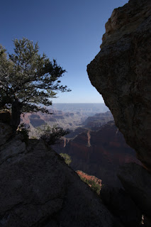
Donning the backpack and with books in hand, we set off on
the short trail out to Bright
Angel Point. This was yet another deep-breath moment for
me. I never used to have such a fear of
heights until I had the kids, now I attempt not to display my angst as they
skip along the narrow paths with ridiculously steep drops on each side (even
typing this causes my heart to constrict, it’s sickening!). The views were naturally stunning. This sight will never get old. We are awed every time.


The North Rim is considerably higher than the South Rim and
the steeper drop to the base means there wasn’t the sense of vastness from this
particular point by the Visitor
Center. At the very end of the trail, after we passed
over a couple of particularly skinny pathways – gulp, gulp, breathe…. – it was
a tad disconcerting to read about the Fault line running through this part of
the Canyon and the earthquakes that are experienced and felt! When we asked the Ranger about this later, he
sort of scoffed and commented that they only register around 0.3 on the Richter
scale. Our feeling was that if they
registered at all, we had the right to be concerned!


Safely navigating back to safer, solid ground further away
from the edge, we then drove out to Imperial Point. This is the highest elevation on this side of
the Park: 8,803ft – quite an increase from the South Rim’s 6,200ft! The wind continued to blow which made
lingering to enjoy the view a little less appealing. We did enjoy this vantage point though. The whole Park is incredible.

From the brochure: Grand Canyon
reveals a beautiful sequence of rock layers that serve as windows into
time. The carving of the canyon is only
the most recent chapter, a geologic blink of an eye, in a long story. That long story includes rock nearly two
billion years old in the bottom of the canyon, land masses colliding and
drifting apart, mountains forming and eroding away, sea levels rising and falling,
and relentless forces of moving water. Several
factors make Grand Canyon’s geology
remarkable. Many canyons form as rivers
cascade among mountain peaks, but Grand Canyon
sits incised into an elevated plateau.
The desert landscape exposes the geology to view. It is not hidden under a cloak of
vegetation. The strata revealed preserve
a lengthy, although incomplete, record of Earth’s history.


On our return, the kids spent some time working on their
Junior Ranger programs. The temperature
really dropped. We were so happy to be
in the camper while the large number of tent campers were fully wrapped in
winter coats and woolly hats. Dave
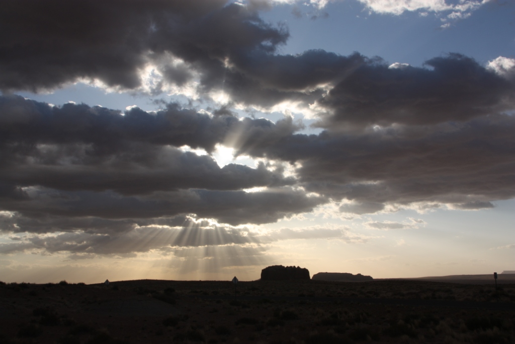
headed back to Imperial Point again in an attempt to secure some night-time
shots. Unfortunately the violent winds
buffeting the camera and the truck meant he was unsuccessful, so nighttime campground pictures had to suffice.


Comments